
Overview:
-The Flood Focus app empowers residents to document and understand the impact of flooding in their neighborhoods.
-Southwest Detroit Environmental Vision's project manager says she was "blown away" by documentation of flooding following record rainfall April 2.
-The data will help "define the geographic extent" of Detroit's flooding problem, says Wayne State professor.
Gabriel Andersen, a 17-year-old senior at César Chávez Academy High School, works at his local grocery store, but he also has an unusual side hustle — documenting flooding in his neighborhood of Southwest Detroit.
After heavy rain, Andersen’s mom drives him around the neighborhood to snap photos of pooling water. He records information such as the type of flooding — outdoor, indoor, flowing, or still water — and location, date and time, and the approximate depth of flooding, which he measures with a yardstick.
“I thought it was a very interesting way for me to make some extra money on the side and also help my community by showing these places where flooding is happening,” Andersen said.
Andersen said he’s taken nearly 200 photos since November 2024.
Southwest Detroit Environmental Vision, a local environmental nonprofit facilitating the app, pays $25 for three photos, said Jaike Spotted Wolf, SDEV’s project manager.
The goal: Community-driven flooding data
The community-driven flood solution app, Flood Focus, was developed in 2022 by Freshwater Future, a Petoskey-based nonprofit that addresses water quality issues in the Great Lakes region, and Earth Economics, a natural capital valuation service.
The data collected by residents is turned into maps and reports for advocacy in areas that deal with residual, recurrent flooding, said Kwamé Hampton, community program coordinator for Freshwater Future.
“It’s really based on the participation of the community, and the solutions are going to be what they would like to see implemented,” Hampton said.
Freshwater Future partners with local groups like Southwest Detroit Environmental Vision, and Hampton said once the data is collected, organizations have the autonomy to decide which areas to address.
Freshwater Future creates a map of the flooding, and partner organizations then share the map and reports with experts, developers, or elected officials, Hampton said. The map is layered with data from a variety of sources, such as rain data from the National Weather Service or information on soil types from soil scientists, he said.
The map can be used to determine which green stormwater infrastructure project suits the target area best, Hampton said. A bioswale, a vegetated ditch that collects and filters stormwater, won’t work everywhere, he said, adding that rain gardens could be more effective than rain barrels in certain areas.
During an online training session for the app, Hampton said these projects are part of low impact development projects that can help catch rainwater or runoff water prior to it reaching the sewer system.
Detroit uses a combined sewer system, meaning stormwater and wastewater from homes goes into one drainage system. During large storms, the system can become overwhelmed, Hampton said during the training session, and the excess runoff water often goes into streets or into residents’ basements.
Most of the flooding the app has documented so far has been indoors, as severe storms often cause basements to flood.
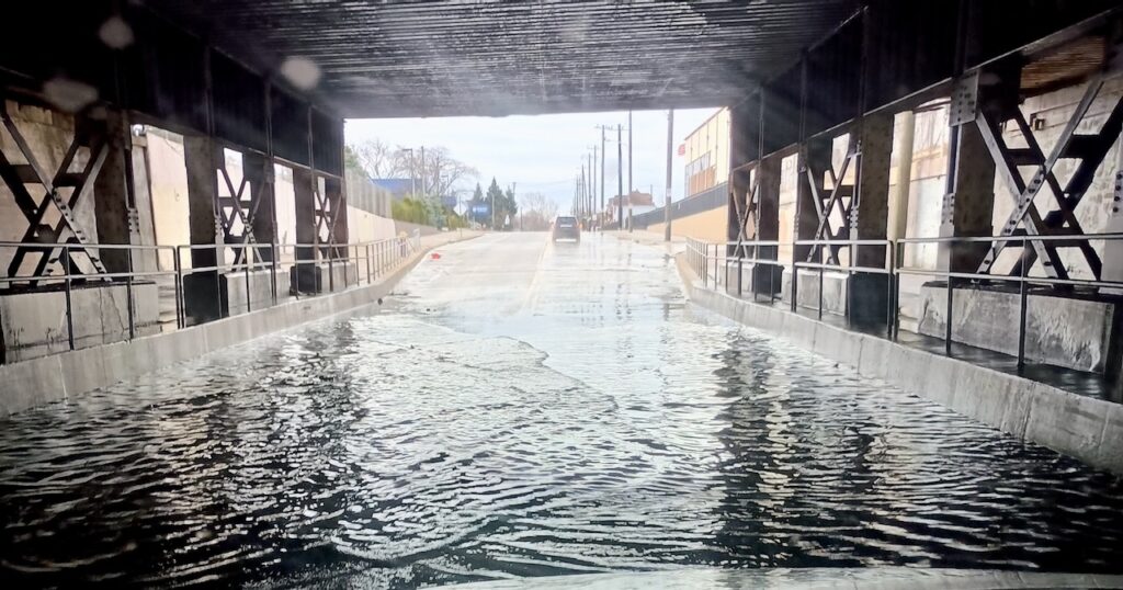
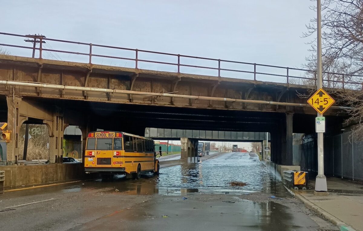
A flooded underpass on Clark Street in Southwest Detroit. Photo via Southwest Detroit Environmental Vision and the Flood Focus app.
App shows aftermath of record April rainfall
SDEV’s Spotted Wolf said flooding is not unique to the area, and “it’s all a mess” throughout Detroit. She highlighted Springwells, a neighborhood located near Ford’s River Rouge plant, needs infrastructure improvements.
While reviewing Flood Focus photos from the aftermath of heavy rainfall on April 2, Spotted Wolf said she was “blown away” by the impact of the flooding.
Cars needed to be towed and access for people using wheelchairs or walkers was blocked by deep water, she said.
On April 2, the Detroit area received 2.18 inches of rain in 24 hours, or roughly two-thirds the amount of precipitation the area usually receives for the entire month of April, according to National Weather Service data, as Planet Detroit reported last week.
Andersen said he’s noticed the most flooding in Southwest in front of sidewalks and driveways, as well as disparities along Vernor Highway.
“On one side of Vernor, the roads are a lot nicer, and then on the other side, it is filled with a lot of holes,” Andersen said. “They get flooded very easily, and sometimes the streets are almost entirely water.”
Spotted Wolf said she wants to make the program accessible to youth, and Flood Future’s Hampton said he’s planning on hosting training sessions in schools, including Cristo Rey and Western.
SDEV began using the Flood Focus app in June 2023, Spotted Wolf said. Since then, three people have used the app: Andersen; another youth resident; and Raquel Garcia, the organization’s executive director, she said, adding that Andersen is Garcia’s son.
Spotted Wolf said finding more participants has been a surprising challenge. The project is funded by a $4,000 grant from Freshwater Future and is not time limited, she said.
Along with the Southwest Detroit environmental group, four other Detroit-based organizations use the flooding app, according to Freshwater Future’s website: 4 Lotz of Reasonz, Jefferson Chalmers WATER Project, the Manistique Community Treehouse Center Detroit, and West Grand Boulevard Collaborative.
MORE REPORTING FROM PLANET DETROIT
Dearborn Heights bears brunt of Ecorse Creek flooding: ‘Nowhere else for the rain to go’
Increasingly heavy rainstorms compound the impact of over a century of development in the Ecorse Creek watershed.
Jefferson Chalmers residents say they were left out of GLWA’s $138M pump station project
The Great Lakes Water Authority says new pump station will improve stormwater management and prevent flooding, but residents contend the project was pushed through with little public input.
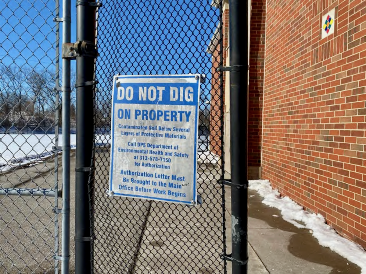
Southwest Detroit school built atop contaminated site not impacted by nearby flood, officials say
Roberto Clemente elementary school sits across the street from homes that were flooded on Feb. 17. The site is capped to prevent exposure to chemicals left over from a legacy of industrial use.
Defining Detroit’s flood problem
Southwest Detroit faces multiple flooding challenges, such as aging infrastructure and combined sewer systems that lead to sewer backups and groundwater intrusion, said Bill Shuster, professor of civil and environmental engineering at Wayne State University.
“If a sewer is plugged and there’s no way for rainfall or snow melt to drain, then it’s going to accumulate in the street,” Shuster said. “If somebody has their downspouts connected to tile drains, that water is going to go right into their basement.”
The app is invaluable in understanding how Detroit geography floods, or does not flood, the Wayne State professor said. The wastewater and stormwater management services that residents rely on have become hyperlocalized, Shuster said. In his view, the data residents collect won’t necessarily help create policy, but rather “define the geographic extent of the problem,” he said.
“I immediately recognized the value of having local and spatially explicit data that’s reported by the people who [live] and [work] in the area and may have had their mobility options significantly narrowed by a flooding event,” Shuster said.
As a hydrologist, he said crowdsourcing data is important, as flooding is highly spatially variable, meaning the way water gets stuck and accumulates depends on how much hard surfaces exist, and the nature of the local sewer system.